


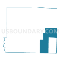
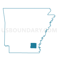
Collins Voting District, Drew County, Arkansas
About
Outline

Summary
| Unique Area Identifier | 526403 |
| Name | Collins Voting District |
| County | Drew County |
| State | Arkansas |
| Area (square miles) | 86.70 |
| Land Area (square miles) | 85.18 |
| Water Area (square miles) | 1.52 |
| % of Land Area | 98.25 |
| % of Water Area | 1.75 |
| Latitude of the Internal Point | 33.50861890 |
| Longtitude of the Internal Point | -91.54764480 |
Maps

Graphs
Select a template below for downloading or customizing gragh for Collins Voting District, Drew County, Arkansas


Neighbors
Neighoring Voting District (by Name) Neighboring Voting District on the Map
- Bowie Rural Voting District, Chicot County, AR
- Bowie Rural Voting District, Desha County, AR
- Boydell Voting District, Ashley County, AR
- Dermott Ward 3, Chicot County, AR
- Enon Voting District, Drew County, AR
- Fountain Hill Rural Voting District, Ashley County, AR
- Jerome Voting District, Drew County, AR
- Lacey Voting District, Drew County, AR
- Selma Voting District, Drew County, AR
- Snyder Trafalgar Voting District, Ashley County, AR
Top 10 Neighboring County Subdivision (by Population) Neighboring County Subdivision on the Map
- Bowie township, Desha County, AR (4,213)
- Bowie township, Chicot County, AR (3,233)
- Franklin township, Drew County, AR (617)
- Cominto township, Drew County, AR (422)
- Collins township, Drew County, AR (235)
- Bartholomew township, Drew County, AR (168)
- Union township, Ashley County, AR (60)
- Bayou township, Ashley County, AR (55)
- Bearhouse township, Drew County, AR (38)
- Bearhouse township, Ashley County, AR (37)
Top 10 Neighboring Place (by Population) Neighboring Place on the Map
Top 10 Neighboring Unified School District (by Population) Neighboring Unified School District on the Map
- Hamburg School District, AR (9,516)
- McGehee School District, AR (6,822)
- Drew Central School District, AR (6,353)
- Dermott School District, AR (3,751)
Top 10 Neighboring State Legislative District Lower Chamber (by Population) Neighboring State Legislative District Lower Chamber on the Map
- State House District 10, AR (27,718)
- State House District 9, AR (24,968)
- State House District 12, AR (22,630)
Top 10 Neighboring State Legislative District Upper Chamber (by Population) Neighboring State Legislative District Upper Chamber on the Map
Top 10 Neighboring 111th Congressional District (by Population) Neighboring 111th Congressional District on the Map
Top 10 Neighboring Census Tract (by Population) Neighboring Census Tract on the Map
- Census Tract 9504, Desha County, AR (3,066)
- Census Tract 802, Chicot County, AR (2,393)
- Census Tract 4901, Drew County, AR (2,380)
- Census Tract 9601, Ashley County, AR (1,928)